An Infrastructure That’s Built For Industry
If you want to ship it, fly it, rail it or drive it…we can help you get “it” anywhere. That means you’re connected to your markets both nationally and globally. The Pensacola MSA provides direct north-south and east-west connectivity, access to national and global markets and the ability to reach your customer base efficiently.
The Greater Pensacola area is accessed east/west via Interstate 10 (I-10) which spans a total of 2,460.34 miles from Los Angeles to Jacksonville. Interstate 10 provides an access point to Pensacola from the Alabama state line. With a north-south connector, Interstate 110 (I-110) extends from I-10; south 6.94 miles, to the heart of Pensacola’s business district and Palafox Street; leading into the Port of Pensacola.
In addition, Escambia and Santa Rosa counties are served by three federal highways, eight state highways, approximately 44 county roads and numerous local streets giving businesses, residents and visitors convenient and accessible travel options. Our transportation network is perhaps why the Texas A&M Urban Mobility Study (2012) said Pensacola is one of the least congested cities in the U.S.
Direct rail service to Greater Pensacola is provided by Rail America. This extensive railway service network connects Greater Pensacola to every major population center in 23 states east of the Mississippi River and Canadian provinces, Quebec and Ontario.
Infrastructure At A Glance
| Federal Interstates | I-10, I-110 |
| Federal Highways | US-29, US-90, US-98 |
| State Highways | SR-4: 20; 85; 87; 89; 97; 189; 285 |
| Rail | CSX Transportation, Genesee & Wyoming (Alabama Gulf Coast) |
| Airport | Pensacola International Airport (PNS) |
| Port | Port of Pensacola |
A Natural Deep-Water Port
The Port of Pensacola, owned and operated by the City of Pensacola, encompasses 50 acres on the Gulf of Mexico (11 miles from the sea buoy) via the Caucus Channel. The Port has unique qualities and is positioned as an emerging leader in offshore oil and gas vessel services. The Port of Pensacola currently offers a variety of services including:
- Abundant on-dock rail
- Six berths, ranging from 400′ to 540′ in length and 15′ to 33′ in depth
- A full range of stevedoring services
- Shore power station for electrical service
- Seven existing warehouse facilities with space availability
- 10 +/- acres for marine light manufacturing, fabrication, maintenance and repair or warehouse facilities
- Foreign Trade Zone (FTZ #249)
- Enterprise Zone (EZ #1702)
- The Port of Pensacola is also designated in the M-10 Corridor and part of the Unites States’ marine highway network system with connections to other major seaports.
An International Airport
Owned and operated by the City of Pensacola, Pensacola International Airport (PNS) is the largest airport between New Orleans and Jacksonville. American Airlines, Delta Air Lines, Frontier Airlines, Silver Airways, Southwest Airlines, and United Airlines provide daily non-stop service to 18 nonstop destinations. Pensacola International Airport accommodates more than 1.6 million passengers per year and generates an annual economic impact of over $565 million.
Passengers in 2017 (1.6M)
Over 6800 daily seats
Served by 6 Airlines
- American
- Delta
- Frontier
- Silver Airways
- Southwest
- United
- Two-story terminal, 159,000 square feet
- Two-story concourse, 10 gates, 10 new loading bridges
- Multi-story parking garage with skyway (963 spaces)
- Main surface and shuttle parking lots (1,368 spaces)
- Runway 17-35: 7,004′ in length, 150′ in width
- Runway 8 – 26: 7,000′ in length, 150′ in width
- Foreign Trade Zone (FTZ #249)
20+ Non-Stop Destinations
- Atlanta
- Austin
- Charlotte
- Chicago Midway
- Chicago O’Hare
- Dallas Ft Worth
- Dallas Love
- Denver
- Houston Hobby
- Houston Intercontinental
- Kansas City
- Miami
- Nashville
- New York
- Orlando
- Philadelphia
- St Louis
- Tampa
- Washington DC
- and more
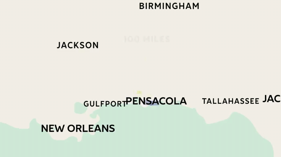
Distance to Markets
| City | Distance in Miles / Direction | Drive Time |
| Mobile, AL | 58.5 / West | 56 minutes |
| Panama City | 103 / East | 2 hours, 12 minutes |
| New Orleans, LA | 203 / West | 3 hours |
| Birmingham, AL | 250 / North | 4 hours |
| Atlanta, GA | 322 / Northeast | 5 hours |
| Jackson, MS | 250 / Northwest | 4 hours |
| Nashville, TN | 440 / North | 6 hours, 45 minutes |
| Chicago, IL | 915 / North | 14 hours |
| Washington, DC | 960 / Northeast | 14 hours, 30 minutes |
| Source: Google Maps, updated 02/2013 | ||
Nearest Airports
| Name / ID | Associated City and Distance1 | Longest RunwayLength / Width | Acres | ControlTower |
| Pensacola International Airport (PNS) | Pensacola, FL | 7000 ft./150 ft. | 1,400 | Yes |
| Ferguson Airport (82J) | Pensacola, FL | 3200 ft./200 ft. | 120 | No |
| Innisfree Jet Center (KPNS) | Pensacola, FL | 7000 ft./150 ft. | 1,400 | Yes |
| Mobile Regional Airport (MOB) | Mobile, AL | 8502 ft./150 ft. | 1,717 | Yes |
| Mobile Downtown Airport (BFM) | Mobile, AL | 9,600 ft./150 ft. | 1,650 | Yes |
| Northwest Florida Regional Airport (VPS) (Eglin AFB) | Fort Walton Beach, FL | 12,005 ft./ 300 ft. | 131 | Yes |
| Northwest Florida Beaches International Airport (ECP) | Panama City, FL | 10,000/150 ft. | 4,000 | Yes |
| Sources: city-data.com; updated 02/2013 | ||||
Nearest Seaports
| Name | Distance in Nautical Miles | Services |
| Port of Pensacola | — | Stevedores, Steamship Agents, Permits, Tugs / Pilots / Line Handling |
| Port of Mobile | 81 | 400-Ton Lift / Barge and Rail Logistics, Specialty Rigging and Heavy Transport, Engineering and Planning Services. |
| Port of Panama City | 93 | Steamship Agents, Customs Brokers, Harbor Pilots, Towing and Trucking Contractors, Stevedores, Security |
| Source: Greater Pensacola Chamber; updated 02/2013 | ||
Regional Motor Freight & Contract Carriers
| Company | Services / Terminal |
| Yellow Freight | North Central Pensacola |
| Viking Freight | North West Pensacola |
| Roadway Express | North West Pensacola |
| Tiger Motor Freight | Central Pensacola |
| American Freight & Trucking Companies | West Pensacola |
| Saia Motor Freight Lines | Northwest Pensacola |
| International Freight Brokers | |
| Great Circle Shipping Corporation | Southwest Pensacola |
| Sources: Greater Pensacola Chamber; updated 02/2013, (partial list) | |
Parcel Carriers
| Name | Latest Drop-Off | Earliest Delivery |
| DHL | 5 p.m. | 10:30 a.m. |
| FedEx | 6:45 p.m. | 8 a.m. |
| Greyhound Package Xpress | Check Local Route Schedule | Check Local Route Schedule |
| UPS | 6 p.m. | 8 a.m. |
| US Postal Service | 5 p.m. | 9 a.m. |
| Sources: Greater Pensacola Chamber, updated 02/2013 | ||